

We create maps and models for permaculture designers, landscape architects, land owners, and a regenerative property developers. From Initial surveys to detailed 3D land models, our maps deliver clarity and accuracy, ensuring cohesive communication and decision-making.
MAP YOUR PROPERTY
CONTEXT
For a handful of countries, high-resolution topographic data is available online. This enables us to process and create high-quality maps remotely. If the data of your property is available - we can create maps for you!
Alternatively, a topographic survey may provide a solution. To learn more about topography and land survey methods, click here.

TYPES OF MAPS:

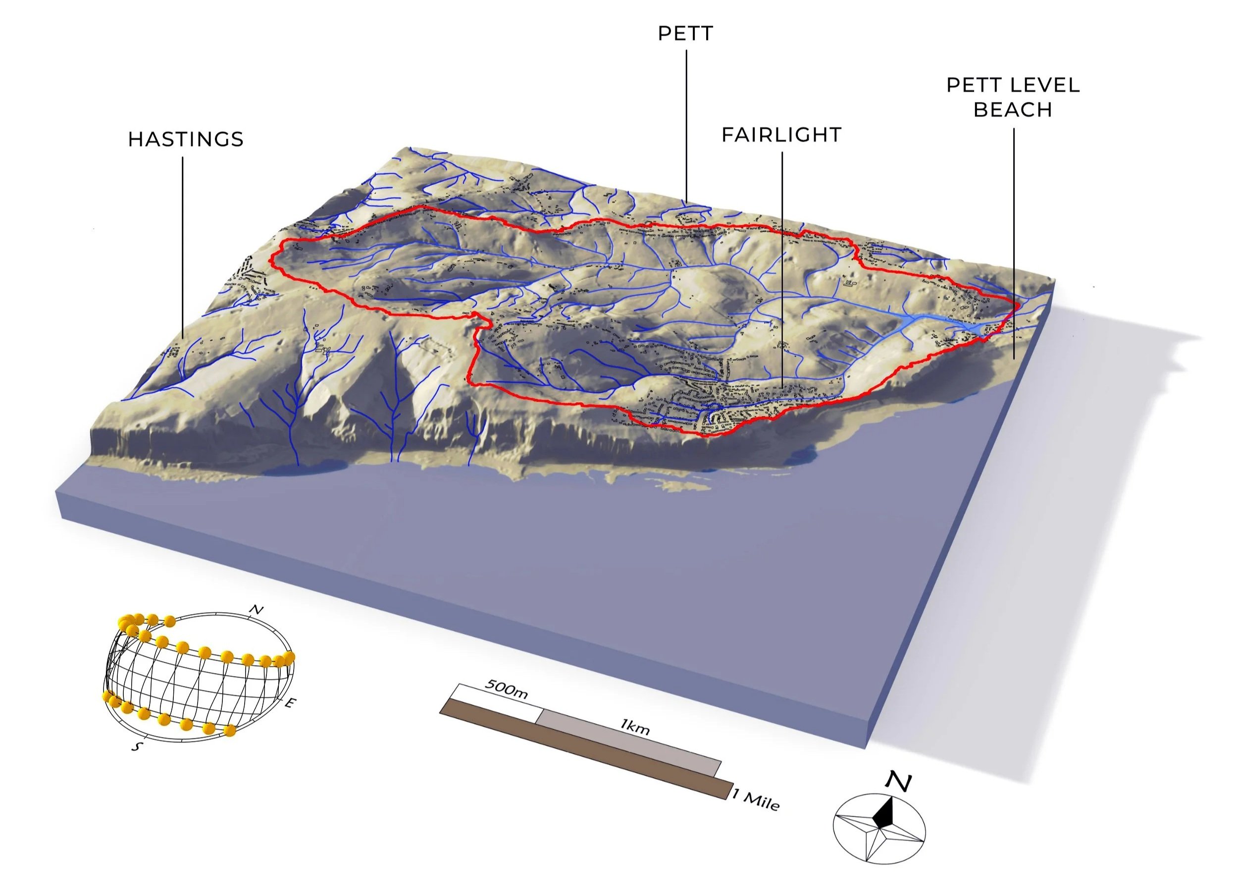
3D LAND MODELS

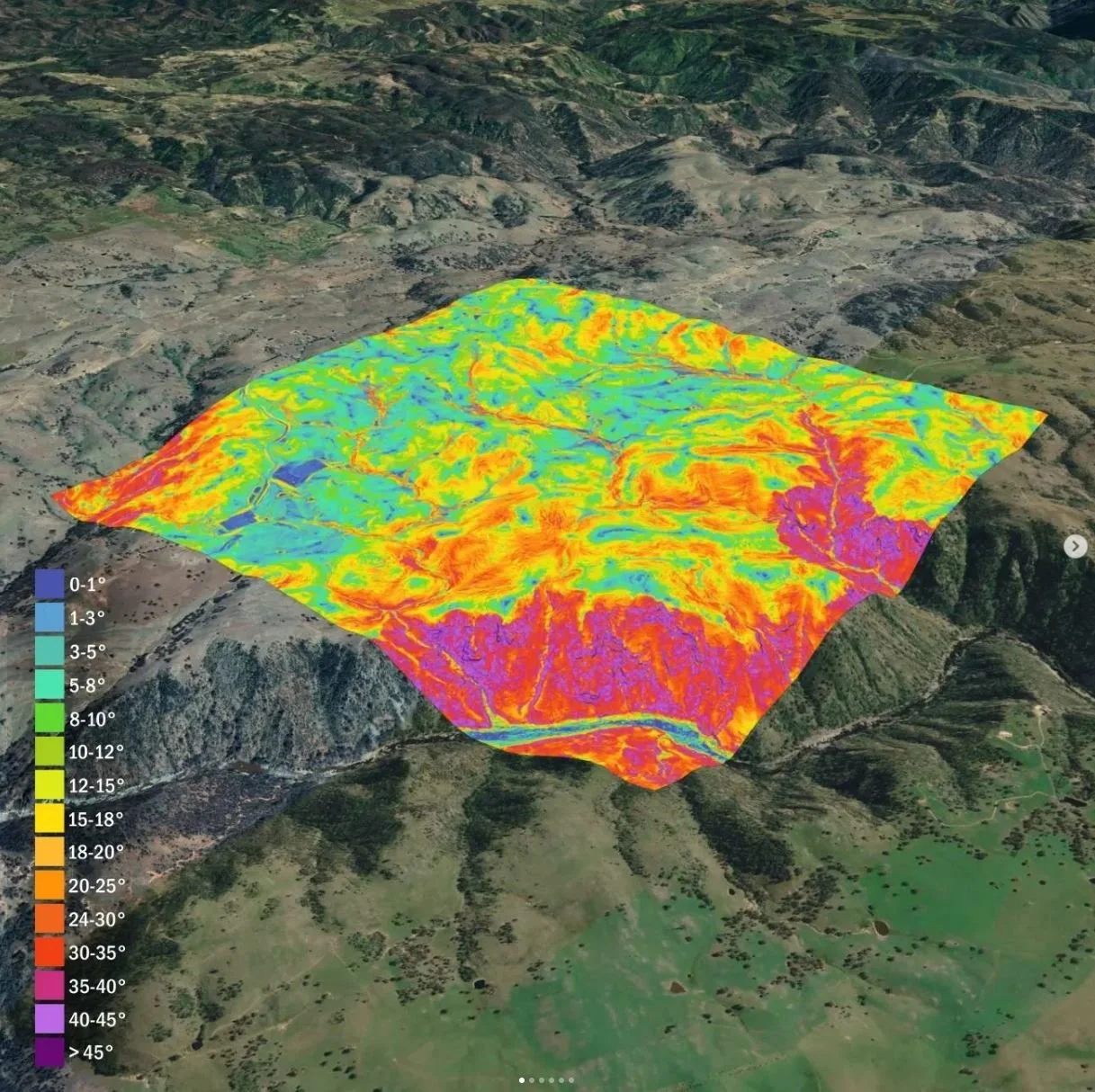
DATA ANALYSIS MAPS
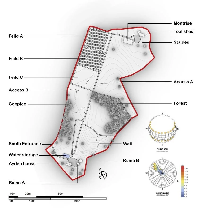
BASE MAPS

VISUALIZATIONS
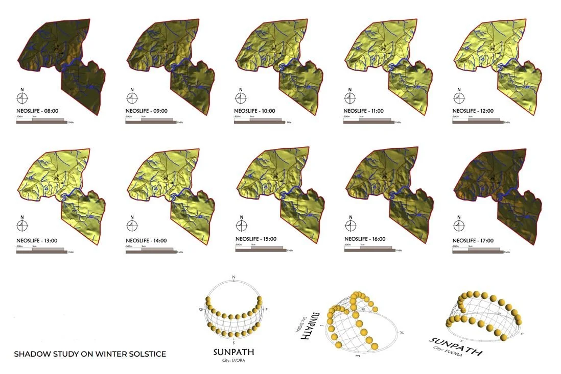
SUN STUDIES
“Well above my expectations”
“We recently bought a very complex 70 HA terrain on a mountainside in SW Portugal and needed to understand a lot about the property in order to begin our project. I'm really happy with Shan's work. She handled business clearly and in a well organized manner. Well above my expectations.


-S. RAPIER (PORTUGAL)
“This collaboration has opened up opportunities for greater impact”
“ This collaboration has opened up opportunities for greater impact and more refined solutions, especially in complex fields like regenerative landscape design. The synergy between our shared values of ecological integrity and regenerative design has enabled us to work together effectively in presenting detailed material in a format that is both easily understood and educational.”
B. KIRK - Greencurves (URUGUAY)
ITEM PRICES:

1. Processing & delivery of topography data
This first essential step unlocks all of the following available items. For architects or similar, we can deliver this as a stand alone item.
Deliverable: 0.5m & 1m contours. 3d CAD format & pdf including border
€45
2. Data analysis maps
These maps reveal and highlight important features of your property - like where water flows (drainage), natural catchment areas (basins), sun exposure (aspect), land capability, (slope) and elevation (altitude). These insights help you make optimized decisions about where to build, plant, or manage your land. We turn complex data into comprehensive and attractive visuals.
Deliverable: PDF maps for drainage, slope, altitude, basins, & drainage.
€245
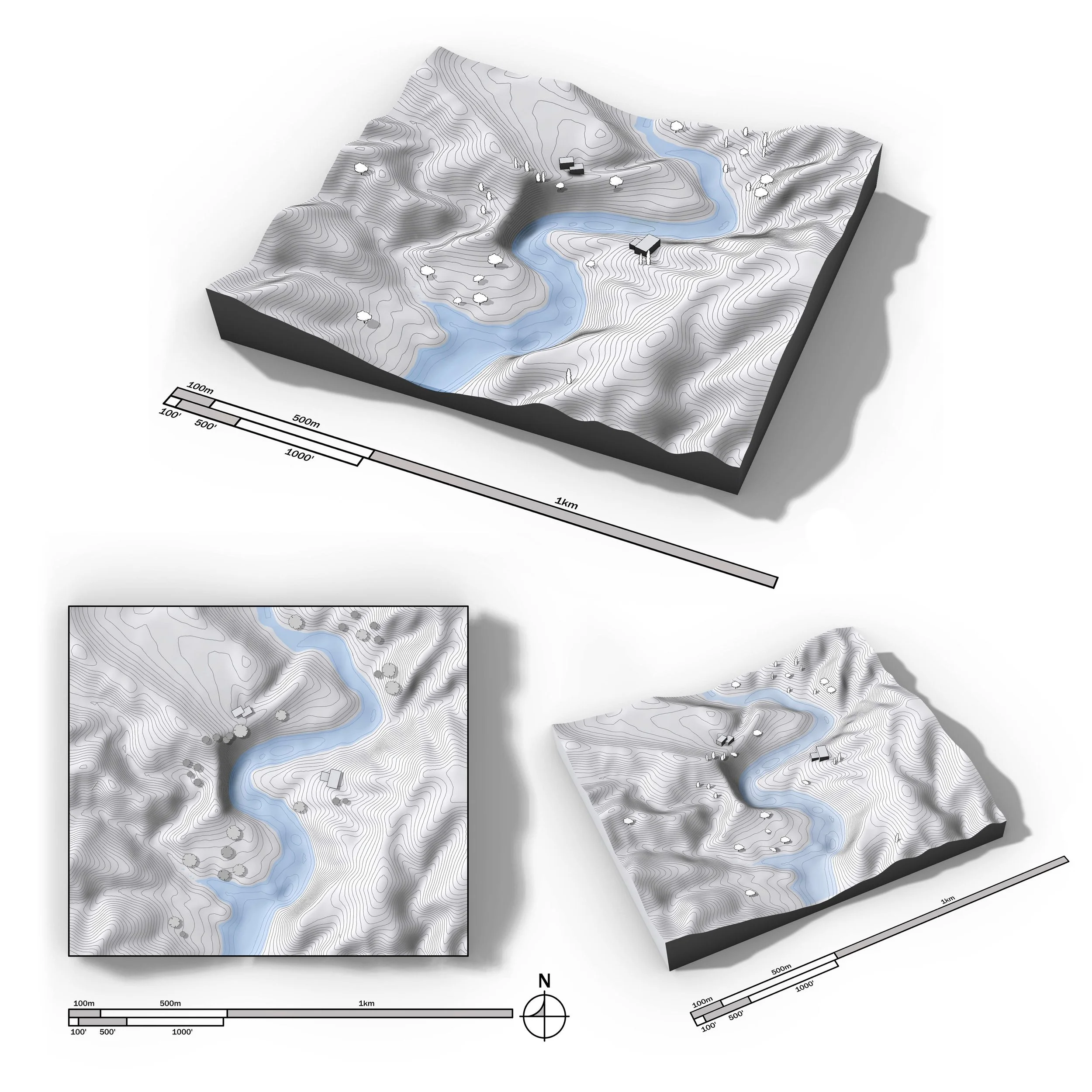
3. 3D model of your property land form
Precise digital 3d land models accurately capture the existing terrain, providing a powerful resource for planning, design, and analysis. Perfect for communicating your vision, refining layouts, and showcasing property potential.
Deliverable: high-res images of the land 3D model including property border and water features.
Option to display existing roads, trees, buildings, & labels within the 3d model can be requested. This may involve an additional charge depending on complexity.
€245

4. Sun & Shadow studies
Optimize land use and design with detailed sun study maps. These maps illustrate sunlight exposure throughout the day and seasons, helping to plan for shading, solar energy, plant placement, and outdoor living spaces. Essential for energy efficiency, agriculture, and comfortable site design.
Deliverable: high-res PDF’s displaying sun/shadow throughout the day on both the summer and winter solstice. (Image per hour on the darkest/shortest and longest day of the year)
€245

5. 2D base map to scale with features labelled
Gain a zoomed-out perspective of your land with a base map. These maps define boundaries, terrain, (topography) orientation, and existing features.
A base map may serve as a foundational document for notes, designs, and observations. Ideal for planning, analysis, and long-term project development. Includes sun and wind rose.
Deliverable: high-res PDF’s
€345
PRICING PACKAGES:
PACKAGE A
All map items (1-5)
€860
PACKAGE B
Any three map items
€450
“Highly recommended”
Shan assisted us with some mapping for our 20ha property in Rogil and we are very happy with the results & the pleasant cooperation. Highly recommended.
- B. VAN OPPENRAAIJ (PORTUGAL)
“seamless and insightful”
Shan provided valuable consultation for United Designers on a client project in Greece, where we conducted detailed LiDAR scans of the site. Once the survey was completed, Shan created precise shadow studies using high-resolution drone data—offering a beautifully clear visual of how sunlight and shade moved across the landscape throughout the year.
Working with Shan was both seamless and insightful. She brings a quiet confidence to her work—highly professional, communicative, and deeply focused. Her ability to translate raw data into meaningful, design-relevant insights made a real difference in our process.
We’re grateful to have her in our extended team and look forward to future collaborations.
W. KIRKEGAARD (HOLLAND)
NEXT PRACTACLE STEPS:
Contact us via WhatsApp : +351 910 763 508 (Shan)
Or fill in our online order form here
What we’ll need to get started on a project:
A pin of the property (or address)
The border of the property (chat to us if you need help with this)
Special requests or specified labels
Aesthetic preferences (e.g. style of the 3D model)
Payment 50% upfront (remaining balance to be settled upon completion)
Delivery time: 5- 20 working days
Following delivery, you have 7 days to respond with any final changes at no cost (we’ll also check in along the way to ensure we’re on the ‘right track’ prior to completion)